GREEN LANE
CRESSEY'S CORNER TO JOHNSON'S CORNER
Cressey's Corner, named after the butcher's shop on the right of the row. A postcard.
Looking down Green Lane from Cressey's Corner. A postcard.
A 1960s view taken from Halfpenny Lane. A Firth postcard.

The same area in 1978. The large house on the left with the tall chimneys called Angus House was built for Dr Steven in 1897. The surgery in front and to the side was opened in 1911. Photo - Dr J Gatecliff.
The white houses on the right are part of the first estate of semi-detached houses in Featherstone built by William Sawyer in 1933-34. Photo - personal 2020.
A postcard view showing further along Green Lane.
The same view in 1990. Photo - Dr J Gatecliff.
A few shops have always been part of Green Lane. Photo uploaded to Featherstone Bygone Days by Eileen Sparling.
It was bought by John George Maxwell. Photo - Wakefield Libraries Collection.
It was owned for many years by Stan Renshaw and was next door to the Chase and Barnsley cobbler's shop. Photo - Dr J Gatecliff 1975.

The plans for St Peter's Mission Church were passed in 1893. Photo - Featherstone Library Collection.
It was closed in 1968 and was sold to the council to be used as a youth club and a playgroup for pre-school children which opened in 1972. It was eventually demolished for the building of council flats in Mount Pleasant Street. Photo - Wakefield Libraries Collection.
The church in its youth club days. Photo - Wakefield Libraries Collection.
John Street with the Eileen Lowe corner shop, formerly Brumby's. Photo - Dr J Gatecliff.
The Social Service Centre was opened in in 1936. It was to provide a base for the unemployed and their wives. As well as social activities the men could learn shoe repairing, carpentry and other useful trades, while the women were taught make do and mend and dressmaking. The women also had a keep fit class. In the 1939-45 war it was made available for social purposes to soldiers billeted in Featherstone. Photo - Barclays Bank archive.
After the war its original purpose was no longer needed. and it was used as a youth club and for the scouts. In 1967 they were told they would have to find a new home as it was about to be demolished as part of a clearance area for aged persons bungalows. Vandals hastened the project by setting it on fire. Photo - Ian Dransfield.
Looking up Green Lane from the Welfare Institute. The back-to-back streets on the right (where the horses and carts are) were demolished in 1960.
The council had a clearance order for the south side of Green Lane which included the back-to-back streets, the disused Methodist chapel, the Social Service Centre and Duke Street. This shows the Social Service centre has gone, and Duke Street ready to be demolished. Photo - Dr Gatecliff Collection.
The cleared land became the site for Greenside, an estate of bungalows for old people. John Street at the other side of Green Lane was being demolished. Photo - Dr J Gatecliff 1972.
The Greenside bungalows. Photo - personal 2020.
Featherstone Working Men's Club (Green Lane Club) opened in 1904. Photo - Featherstone Library Collection.
In 1976 the Featherstone Working Mens' Club committee decided the building should be modernised. The tenants of the shops at the front were given notice to quit and a new frontage was built. Photo - personal.
A block of four back-to-back houses was built at the top of Earle Street in the 1880s. They were demolished in the 1960s along with the other back-to-back houses along Green Lane. Photo - Dr Gatecliff Collection.
Public toilets were built by the council on that site c1964, but they were an immediate target for vandalism, and after spending years and money on trying to make them vandal proof the council admitted defeat and they were demolished.

The Assembly Rooms opened in 1898. It was just a large brick building with lots of windows. This was the Earle Street side. It contained a large hall upstairs and a workingmen's club on the ground floor. In 1920 the Government set up a welfare fund for miners to be paid for by a levy on coal production. In 1922 Featherstone miners received a £5000 grant from the fund, and it was decided to buy the Assembly Rooms and turn the building into a Miners' Welfare Hall. The official opening was 2 February 1925. Photo - Featherstone Library Collection.
 |
The entrance to the Featherstone Main Colliery Athletic Club was at the end of the building in Pretoria Street. In 1919 the club was in court for serious breaches of the Licensing Laws. The magistrates ordered its closure for 12 months, but it never reopened. There is no known photo of the front. Photo - Featherstone Library Collection.
The 1923 refurbishment of the assembly rooms included a new entrance, installation of electricity, repainting and new heating. The West Riding County Council library, on the left, was opened in 1934. Previously it was situated in the Welfare building. Photo - Featherstone Library Collection.
The Welfare building was sold to Alexander Rose Ltd in 1968 for £9,000. Photo - Rich Short (Featherstone Bygone Days). James Bros furniture firm took over part of the building and complained to the council that there were no road signs to let prospective customers know they were in Featherstone, and they were losing trade. The council agreed to buy signs and erect them.
One of the road signs. Photo - Dr J Gatecliff.

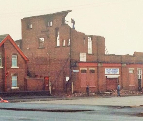
This photo from the Featherstone Heritage Group shows the back and Pretoria Street side of the building. The presence of the fireman gives a good impression of the size of the Assembly Rooms. The accidental fire caused so much damage the building had to be demolished. The following three photos are by Sam Spragg.
|


A new commercial building was built when the sire was built and was called Warwick House. Photo - Google Street View.
FROM JOHNSON'S CORNER TO "DOWN GREEN LANE"
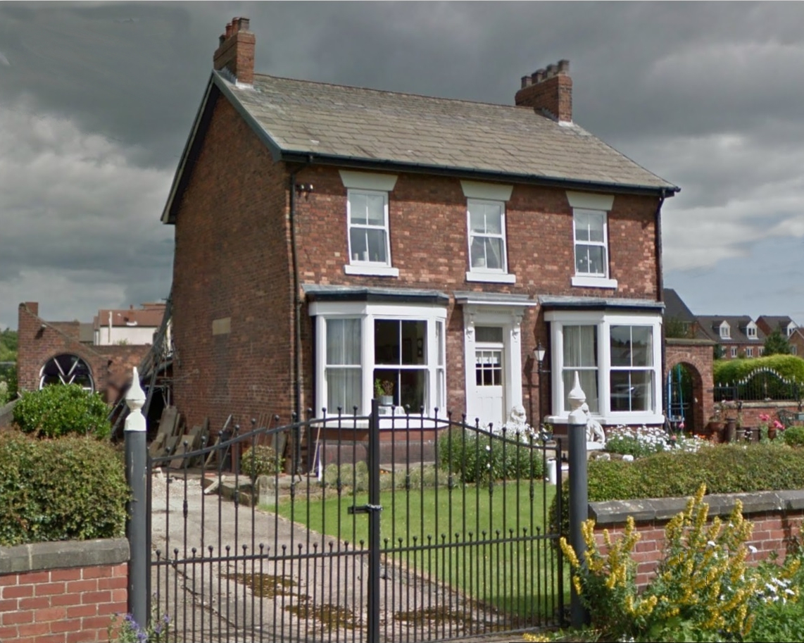
Green Lane House was built to house a manager or undermanager from Featherstone Main Colliery and then Ackton Hall Colliery. Photo - Google Street View.

Across the road was Ossie Wilks' scrapyard. Photo - Dr J Gatecliff. After his death it was turned into a yard to keep vehicles on the road rather than scrap them. Photo - personal.
Further down Green Lane four houses were built for colliery officials. Photo - Google Street View.
This was the first muckstack for Ackton Hall Colliery, started in the days when george Bradley owned the colliery. Photo - Dr J Gatecliff.
When Lord Masham bought Ackton Hall colliery from George Bradley he increased the coal output and so had more waste material to get rid of. He started a new muckstack south of the railway which led to numerous complaints in the 1920s about dust and fumes. The third Lord Masham promised a new stack near Featherstone Main Colliery which would involve an aerial flight being installed. It was delayed by the death of Lord Masham and the sale of the colliery in 1926 to the company that owned Featherstone Main and it was probably 1927 when it began.
The above photo (Featherstone Library Collection) shows the start of the aerial flight at the Green Lane end, and the Frith postcard below show the tipping end after about 40 years.
The colliery complex included a brickyard and a clay quarry. The above photo photo of the brickyard is from the Featherstone Library Collection, that below of the disused quarry is by Dr J Gatecliff.

Once past the quarry the remainder of Green Lane was just a cart track with fields on both sides all the way to Commonside Lane. There was a good view of Warren House Farm dominated by a Featherstone Main Colliery muckstack. Photo - Dr J Gatecliff.
This photo of a caravan in Green Lane was taken by Dr J Gatecliff.
In 1980 permission was given for the Springfield opencast coal mine. It eventually covered the area from the railway lines to the bottom of the hill at Ackton. The Green Lane area beyond Ackton Hall Colliery boundary was excavated, and the brickyard site and quarry and Warren House Farm were all excavated. A fence was erected in Green Lane to prevent access.
Photo - Les Bowkett (Featherstone Bygone Days).
Part of the opencast mine. Photo - Les Bowkett (Featherstone Bygone Days).
By 1992 coal production had ceased and the site was landscaped. Green Lane was restored as a proper road instead of a cart track, and the land between it and the railway lines became an industrial estate.
Photo - Google Street View.
The new road had trees planted along it which blocked out the view of Ackton and North Featherstone. Photo - Google Street View.
 The north end of Featherstone Lane. Photo - Featherstone Library Collection.
 Further down the lane in 1971. Photo - Dr J Gatecliff.
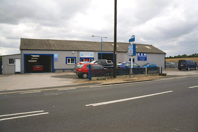 Brooksbank's Garage in 2014. Photo - Ian S (Geograph).


_NEW.jpg)